What Is A Drone 3d Model?
A drone 3D model refers to a digital spatial model that is created by using aerial images taken by a drone. The process of taking aerial images to make models and maps is called aerial photogrammetry.
Drones are used for aerial photogrammetry to scan landmasses, buildings, construction sites, and anything else at height. These images are then converted into an accurate drone 3D model using 3D modeling software.
Why Drones Are Great for Aerial Photogrammetry
Drones are easy to use and are a much more affordable option for conducting aerial photogrammetry than using airplanes or helicopters. Drones are also equipped with geotagging technology that automatically embeds geographical data in the pictures’ metadata as it’s being captured.
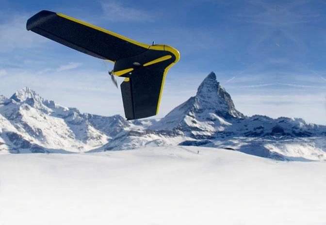 The eBee Classic, a drone made just for surveying and mapping
This data—which includes altitudinal, longitudinal, and latitudinal measurements—is essential to create an accurate 3D model of a subject.
With several 3D modeling software platforms on the market, these images are easily converted into a drone 3D model. The accuracy of the 3D models makes it possible to calculate area, volume, and distance in and around the model.
How To Create A Drone 3D Model
To create a drone 3D model, you need to start with a comprehensive dataset.
Here’s how to gather the data that’s required to create a drone 3D model:
-
Get a drone with a high quality camera. SenseFly’s eBee Classic is a professional drone that is often used for aerial photogrammetry.
-
Set your ground control points (GCPs). GCPs are black and white square points that are placed on the ground around the subject you are surveying. These points have known coordinates and serve as reference points for the drone. Placing these points at the survey site significantly reduces the margin of error in the surveying process and ultimately allows for better measurements within the 3D model.
-
Set up your drone camera and automate flight paths. Make sure you have enough battery life and memory to run the mission. Calibrate your drone to the right angles and set up your gimbal angle, aperture, and shutter speed. Check that you have properly set up the drone to run an automated survey flight.
-
Make sure you survey on a clear day. If you’re putting the work in to survey a subject, you want to be sure that you collect the best data for the 3D model. You also don’t want to endanger any of your equipment. Avoid hazardous weather and cloudy days.
-
Set up your data in drone 3D modeling software. To process your data and create a 3D model, you’ll need the right software to process it (you may also need a GIS specialist, depending on what you plan to do with the model). Industry-specific photogrammetry platforms like Pix4D’s Pix4Dmapper can be used to process your data into 3D models for you.
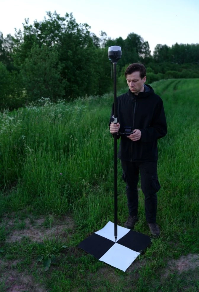 Calibrating GCPs
Getting the Right Data for Your Drone 3D Model
Aerial photogrammetry works by measuring the same subject taken from at least two different locations. The different perspectives are used to triangulate the location of the points in the subject.
The more photos you have, the more location points you’ll have to make an accurate 3D model.
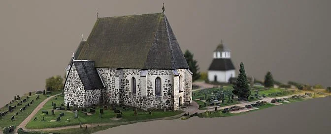 Drone 3D model | Source: Lassi Kaukonen
Considerations when setting up the automated survey flight:
-
Each photo should overlap by 60% to 70% for accurate triangulation
-
Your drone must be between 150ft to 200ft for straight down photos
-
Circle the subject at a high altitude with a 30º camera angle
-
Circle the subject at a middle altitude with a 45º camera angle
-
Circle the lower altitude with a 70º camera angle
-
Keep your subject in the frame by adjusting your radius
Industries That Use Drone 3D Models
Because of their geometric accuracy, not to mention their ease and simplicity of creation, a variety of industries use drone 3D models for numerous applications these days.
Drone pilots working in these industries may provide LiDAR and photogrammetry-made 3D models as one of the outputs of their work, along with photos and videos, and orthomosaics.
Here are some examples of industries that use drone 3D models:
-
Agriculture. The agriculture industry uses aerial photogrammetry to create orthomosaic maps of fields. Farmers use these maps to create remote normalized difference vegetation indices (NDVIs), which allow farmers to see if there is live green vegetation growing in their crops.
-
Architecture & Engineering. Architecture and engineering firms use drone 3D models to create maps of their projects. Architects and engineers will use these 3D models to get funding for projects.
-
Construction. The construction industry uses drone 3D models to monitor the progress of a project, and uses these models for inspections as well.
-
Inspection Service Providers. Inspection service providers use drone 3D models to inspect property and assets safely and more efficiently. Because of the accuracy of these models, they can spot problem areas from these 3D renderings and show them to end users so the information can be incorporated into their maintenance work.
-
Land Surveying. Land surveyors use drone 3D models to map properties, creating historical documentation of changes in landscape.
-
Power Generation. Energy companies are using drone 3D models to inspect their intricate assets and operations from a safe distance.
-
Public Safety. Public safety departments use drone 3D models to map crime scenes, investigate fires, record evidence, and survey natural disasters.
-
Real Estate. Along with real estate drone photography and videography, 3D models and orthomosaics made with drone data have become a go-to resource for real estate marketing, helping real estate agents sell properties even when people can't see them in person.
The Future of Drone 3D Models
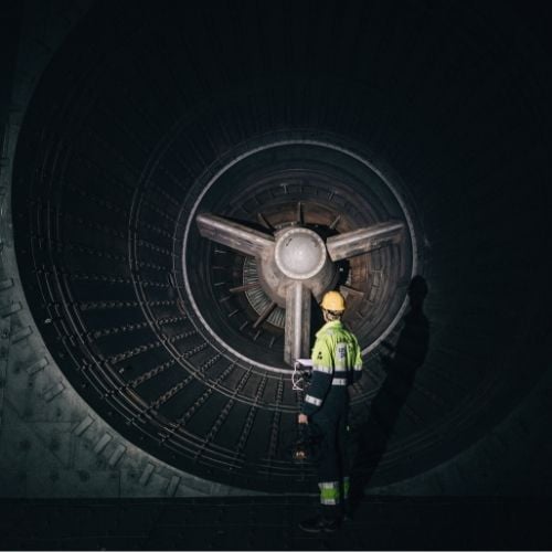
As technology develops, RVIs are being developed with higher payloads capable of carrying different sensors. The Elios 3, pictured below, has a modular payload equipped with a LiDAR sensor that creates 3D maps in real time.
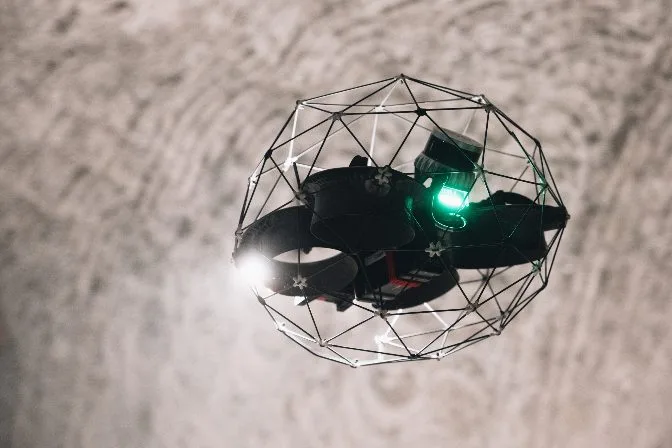
Although primarily used as an indoor inspection tool, the Elios 3's innovative technology makes it easier for inspectors to collect data and spot defects that need to be repaired. The 3D maps provide a historical record of how an asset is maintained throughout its lifetime.